Exploration
Exploration is crucial for future production. Without new discoveries, production decline will accelerate. Today, companies mainly explore in well-explored areas where discoveries are often small. Activity remains low in underexplored areas, where the potential for larger discoveries is greatest. More exploration must therefore be directed towards these areas to ensure sufficient resource growth.
In this chapter:
- Exploration is crucial
- Exploration activity between 2000 and 2025
- Near-field exploration
- New technology increases the value of a unique database
- Great opportunities in underexplored areas
- Unopened areas – a sea of opportunities
- Profitability of exploration 2000–2025
Exploration is crucial
Production on the NCS is in decline as the large fields mature and deplete. As production declines, a significant proportion of the expected production up to 2050 must come from future discoveries. To ensure sufficient resource growth, it is therefore necessary to follow two parallel tracks in the exploration industry (see fact bocx).
Well-explored and underexplored areas
Well-explored areas have a sufficient knowledge base established on seismic, well data and documented discoveries, as well as the most significant plays to be tested. Uncertainty about the resource base is therefore relatively low compared with the original potential. The delimitation refers to how much information there is, seen in relation to the geological complexity of the area.
Underexplored areas are areas where exploration activity has been low in relation to the assumed geological potential.
The first track is swift and efficient near-field exploration This extends the life of existing infrastructure and contributes to production in the coming decades. The second track is targeted exploration in underexplored areas, where the potential for large discoveries is greatest. Both tracks are necessary to support future production.
Exploration activity between 2000 and 2025
Exploration activities on the NCS in the period 2000–2025 have been crucial to maintaining a high production level. New discoveries have added resources which counteract the decline in production from mature fields, and a significant proportion of future production will come from resources proven during this period (Figure 4.1).
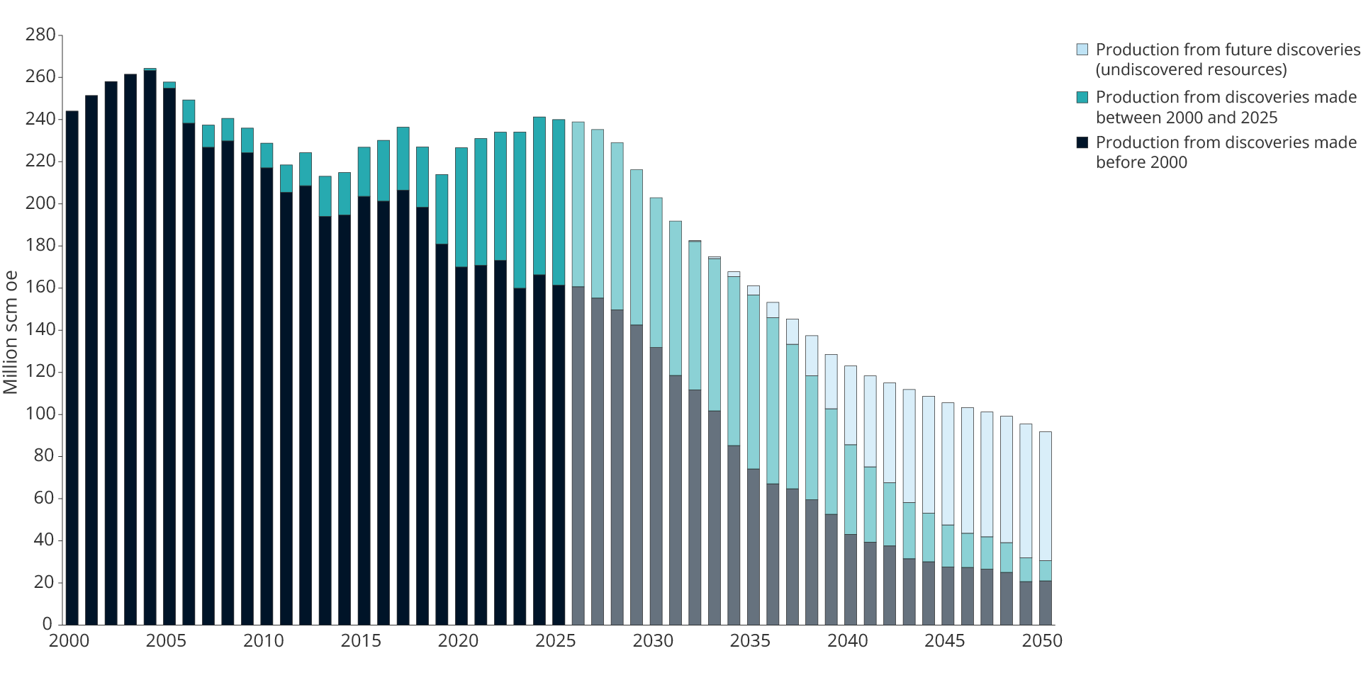
Figure 4.1 Production contribution from discoveries made during different periods
Oil prices have been the single most important factor for developments in exploration activity throughout the period (Figure 4.2). The relationship between price levels and activity is well documented. At the same time, the overall picture shows that exploration activity is also affected by other factors, including framework conditions, access to prospective acreage, the player landscape and the companies' assessment of future prospects and strategies.
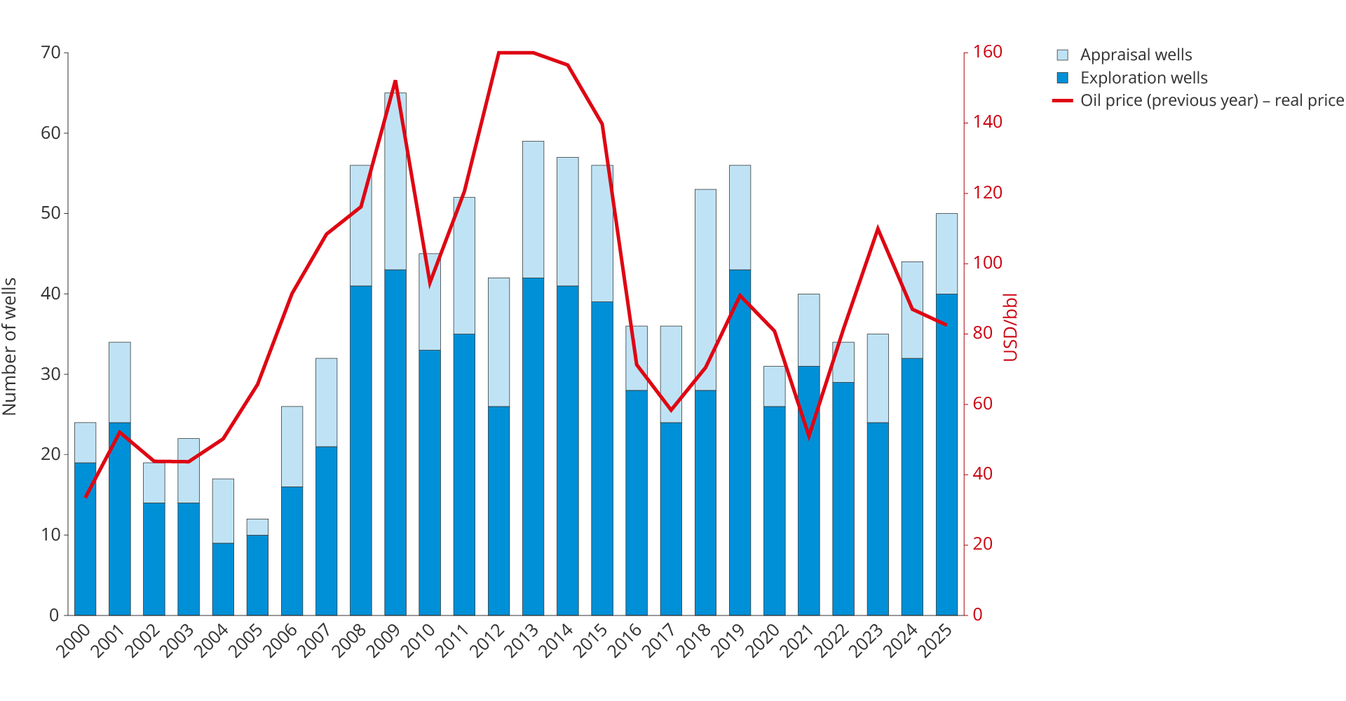
Figure 4.2 Number of spudded exploration wells per year and oil price (previous year)
The government measures implemented in the early 2000s, including the Awards in Predefined Areas (APA) scheme, prequalification and the exploration reimbursement scheme, lowered the entry barriers and helped attract new and smaller companies to the NCS (see fact box).
Measures for more exploration
In the period 2000–2005, the authorities implemented three measures to lower entry barriers and attract more companies to the NCS.
The prequalification scheme (2000) gives companies the opportunity to assess whether they are suitable for participation on the NCS before they commit resources to specific applications. The scheme reduces the threshold for new players and has received great support since it was introduced.
Awards in predefined areas, APA (2003), were introduced as a supplement to numbered licensing rounds to circulate exploration acreage in mature areas. APA replaced the North Sea awards in 1999, 2001 and 2002. Acreage returned by one company becomes available to other companies with innovative ideas. The scheme ensures that active exploration is carried out and that acreage is not left unused.
The exploration reimbursement scheme (2005) gave companies still without taxable income from the shelf the right to be reimbursed 78 per cent of their exploration costs. Companies with taxable income obtained the same tax benefit through ongoing deductions. The scheme ensured equal tax treatment and removed a significant financial barrier for new and smaller companies. The scheme has been discontinued and replaced by cash flow tax in 2022.
The effect of the government measures extended far beyond what oil prices alone can account for. These measures contributed to the extraordinary exploration period from 2005–2014, characterised by an extremely high level of activity, a wide spectrum of companies and major discoveries, including the Johan Sverdrup and Johan Castberg fields.
The drop in oil prices in 2014–2015 was a turning point. Exploration investment was halved and has since remained at a lower level (Figures 4.3 and 4.4). The decline post 2015 was due to fewer companies, lower activity and a lower cost level, partly due to a significant fall in day rates for the lease of drilling rigs.
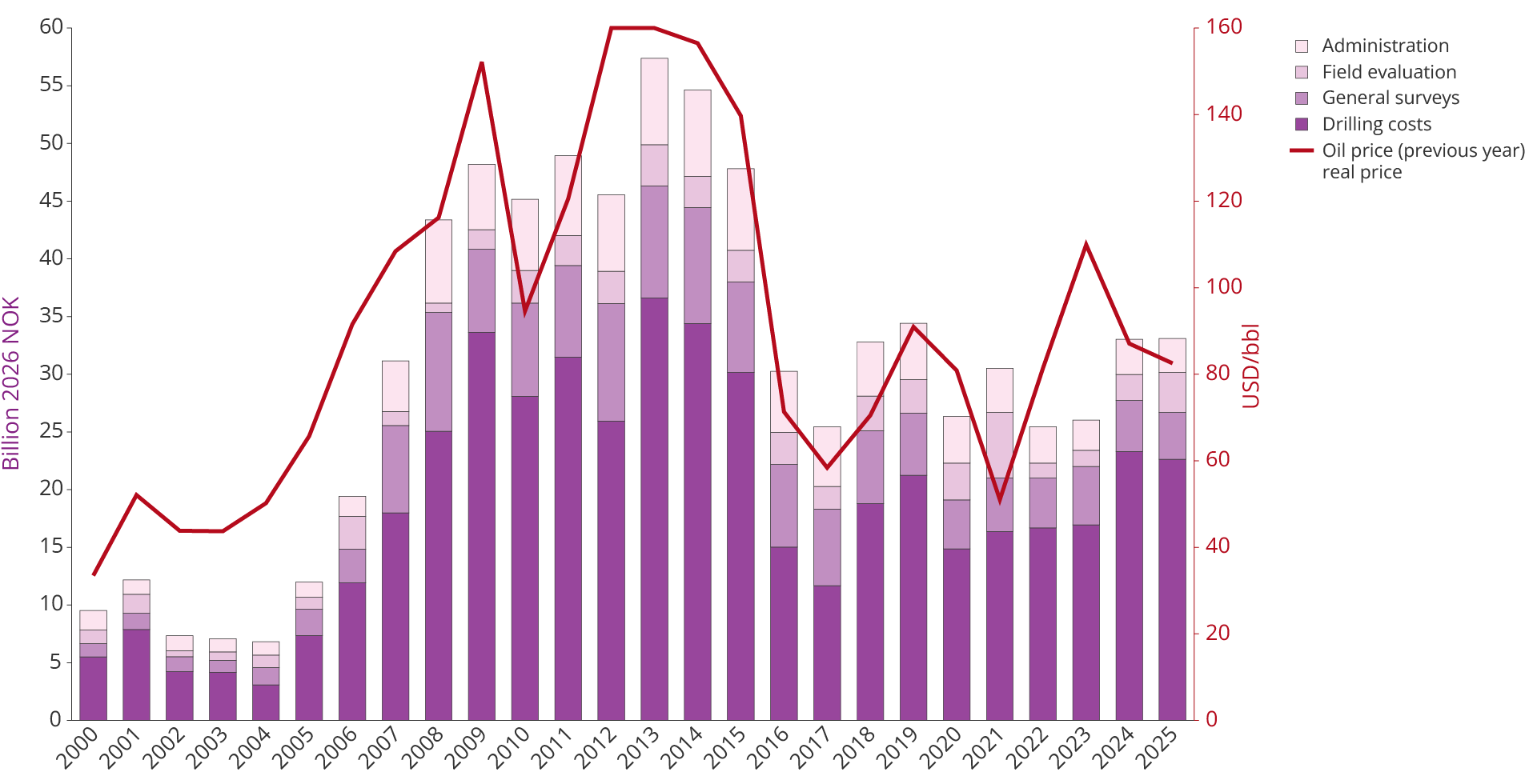
Figure 4.3 Total exploration investment by cost element and development in oil prices (previous year)
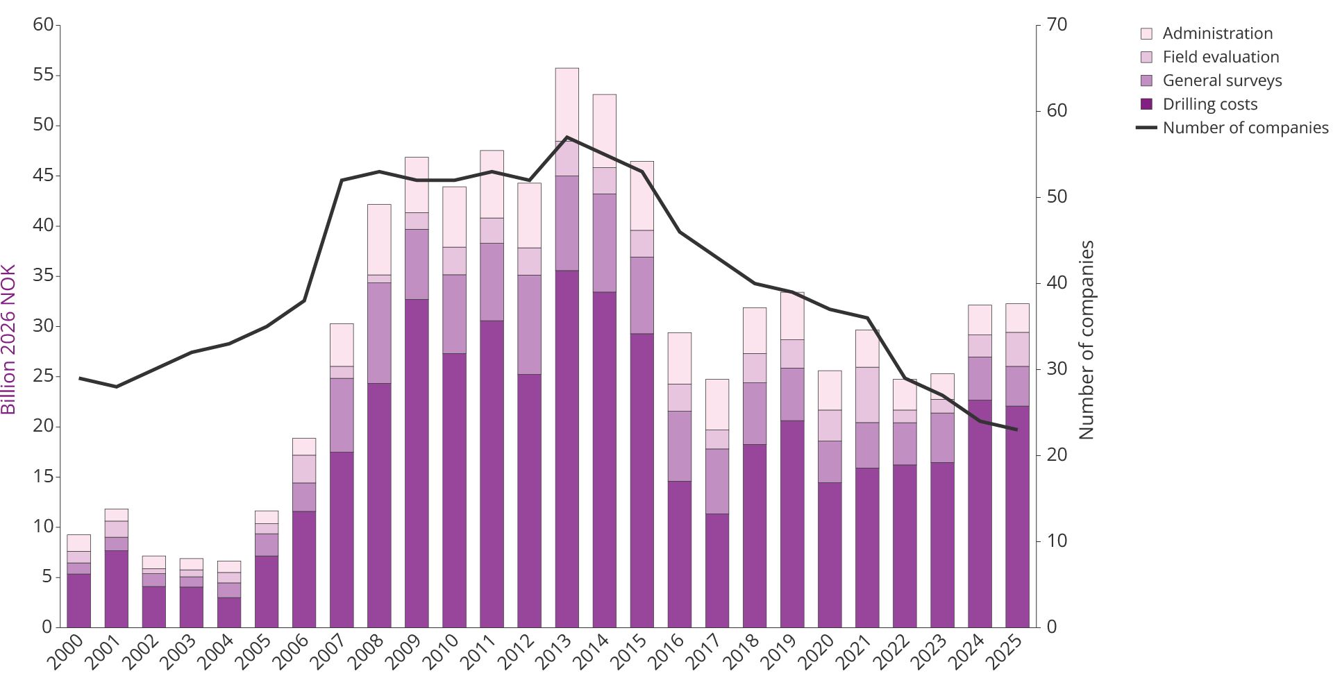
Figure 4.4 Total exploration investment by cost element and development in the number of companies on the NCS
Pressure from the capital markets for cost cuts and predictable cash flows (see fact box) led to a change in the companies' exploration strategies. Exploration became increasingly focused on prospects close to existing infrastructure, with a higher probability of discovery and shorter lead times to production. Near-field exploration became the dominant strategy post-2014 (Figure 4.5).
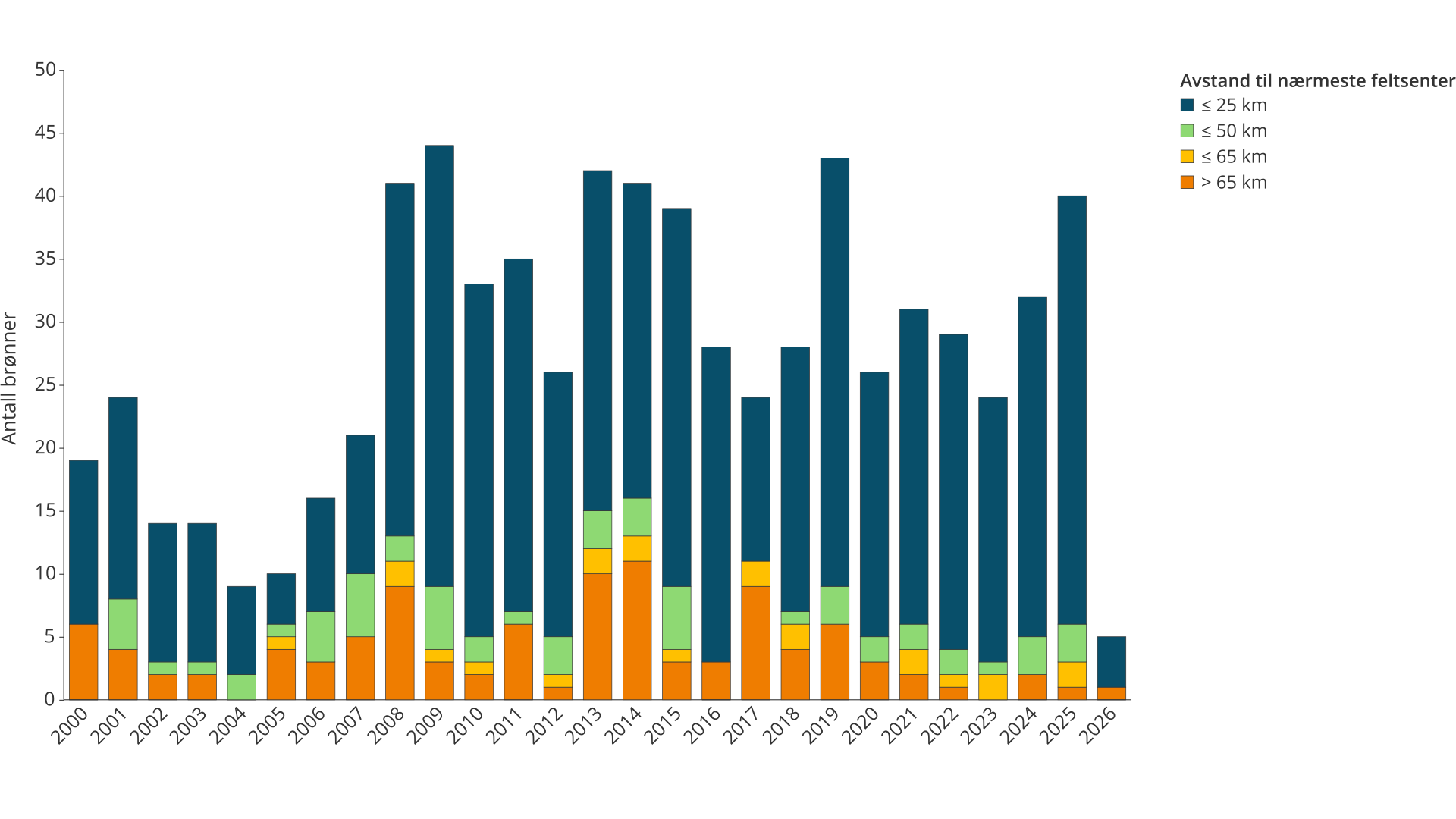
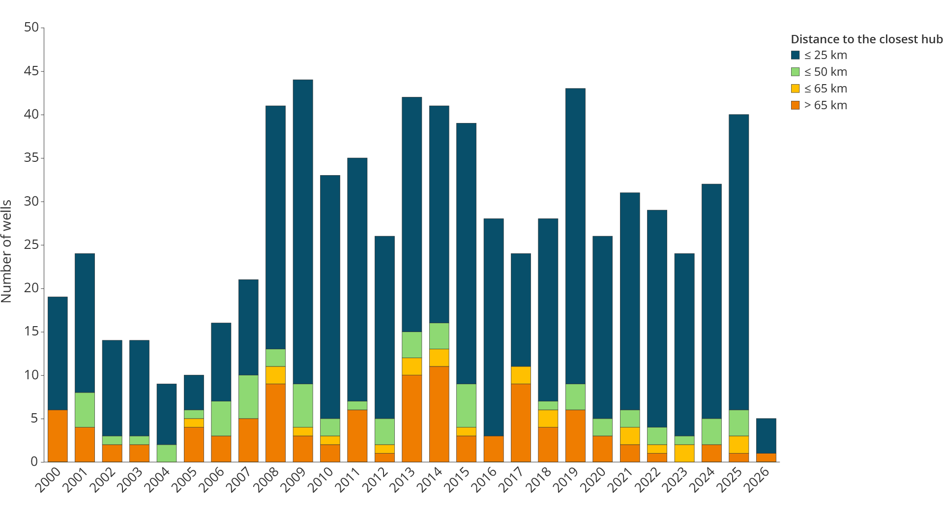
Figure 4.5 Development in the number of exploration wells over 65 km
Capital discipline and willingness to explore
Following the drop in oil prices in 2014–2015, international oil companies were exposed to increased pressure from owners and capital markets to reduce costs, strengthen their balance sheets, increase shareholders dividends and ensure more stable cash flow. This led to a clearer emphasis on capital discipline in the companies' strategies.
Capital discipline affects exploration activity by companies prioritising prospects close to existing infrastructure, which can result in rapid production start-up and short payback time.
The geology of mature areas is better mapped, reducing exploration risk. Proximity to infrastructure also contributes to lower risk in other ways. Wells can be drilled from existing facilities, and discoveries can be quickly phased into existing facilities.
The result is a more cost-effective and selective exploration activity. However, exploration becomes more short-term oriented and less focused on prospects with the potential for large discoveries. Historically, this has been important for resource growth on the NCS.
The consequence is a clear decrease in the average discovery size and fewer large discoveries (Figure 4.6), and resource growth from exploration no longer contributes sufficiently to counteracting the decline in production from existing fields (Figure 4.7). This trend is not only due to the maturity of the shelf. It also reflects the companies' exploration strategies.
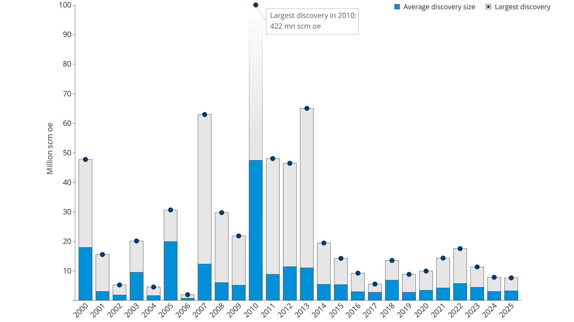
Figure 4.6 Average discovery size and largest discovery per year. Resource class 6 (RC 6) is not included
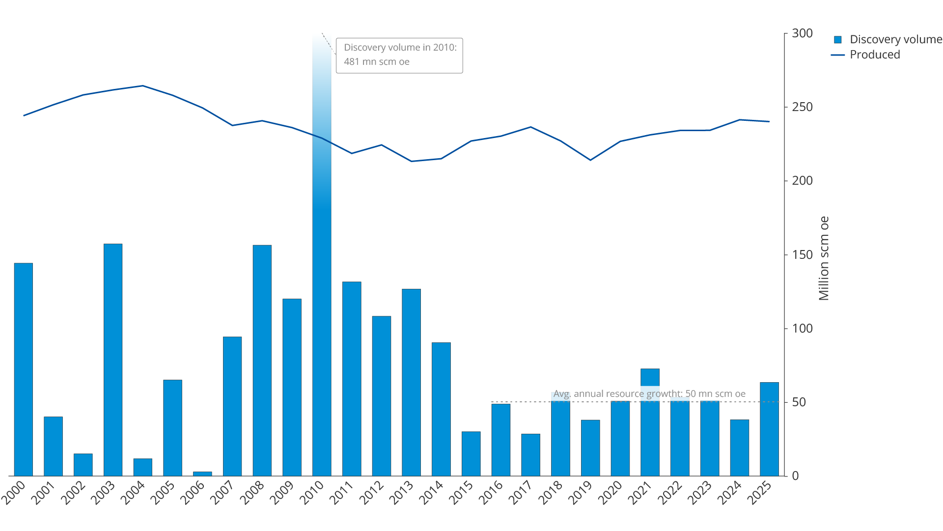
Figure 4.7 Annual discovery volume (including RC 6) and production
Near-field exploration
2025 was the best exploration year in ten years, excepting 2021. 40 exploration wells were completed, and 21 discoveries were made (Figure 4.8). The discoveries have a preliminary total resource estimate of 67 million scm oe.
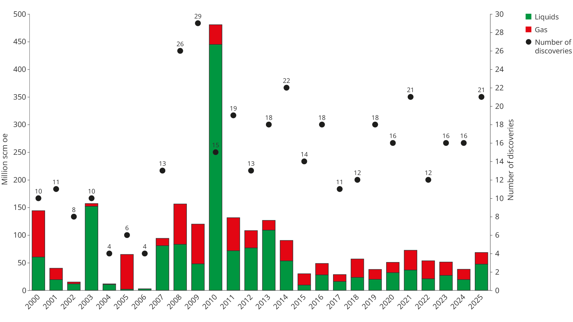
Figure 4.8 Number of discoveries and discovery volume per year
Several discoveries have been made following the implementation of new and advanced technology in seismic imaging, processing and drilling. One example is the exploration campaign "Omega Alfa" (see fact box), which demonstrates how advanced drilling technology provides greater flexibility and makes it possible to test several exploration targets in one and the same well.
"Omega Alfa" in the old Frigg area
Aker BP drilled the "Omega Alfa" exploration campaign with wellbores 25/1-14 and sidetracks A–G around the previously producing fields Frigg and Øst Frigg (the Yggdrasil area in the North Sea). The Frigg area is one of the most mapped areas on the NCS, where the Frigg and Øst Frigg gas fields were developed and later shut down over 20 years ago.
Traditional exploration was long considered to be over. The wells target thin oil columns in the Frigg formation, often below or between old gas contacts, which were historically considered non-commercial or too difficult to prove.
The main objective was to prove and delineate the remaining petroleum accumulations in the Frigg formation, particularly oil that had re-migrated into the Frigg reservoir following previous gas production and depressurisation.
Long horizontal wellbores and multilateral drilling were used, with up to several tens of kilometres of total reservoir exposure – far beyond the norm for exploration wells. Advanced geosteering and real-time data made it possible to keep the wells within thin oil zones with good reservoir quality over long distances.
Discoveries were made in four of the wells, within five accumulations) of the prospects "Omega", "Alfa", "Sigma", "Sigma NE" and "Pi", while "Alfa Sør" was dry. "Sigma NE" (25/1-14 C) was the largest single discovery on the shelf in 2025. The licensees consider the discoveries to be part of the Yggdrasil development (18).
The "Omega Alfa" wells were special because they proved significant volumes of oil in a previously shut down and "fully explored" gas field, by using new precision drilling and long horizontal wellbores. The wells proved thin, remigrated oil zones which can be produced profitably.
The exploration results in 2025, such as the 15/5-8 S (Lofn) and 15/5-8 A (Langemann) discoveries (see fact box), and the "Omega Alfa" exploration campaign (25/1 14 A-G), demonstrate that technological developments have strengthened the companies' ability to exploit the existing knowledge base on the NCS.
«Lofn» and «Langemann» – discoveries in explored terrain
In the Sleipner area, one of the most explored areas on the NCS, hydrocarbon-bearing sandstones were proven with the help of analyses of new, improved seismic data and the re-analysis of old core samples. Wells 15/5-8 S (Lofn) and 15/5-8 A (Langemann) in production licence 1140 have proven remaining resource potential in the area.
The discoveries consist of gas and condensate in high-quality sandstone reservoirs in the Hugin formation (Middle Jurassic) and are classified as HPHT discoveries. Recoverable resources are preliminarily estimated at 5–18 million scm oe (19). Proximity to existing infrastructure provides the potential for efficient phasing-in, low development costs and relatively low emissions per unit produced.
Artificial intelligence (AI) and machine learning (ML) can help increase exploration efficiency. This applies particularly to more rapid seismic interpretation and more systematic analysis of existing well data. In well-explored areas with high data coverage, this can help uncover overlooked potential for oil and gas and re-evaluate previously downgraded prospects.
Most of the discoveries in 2025 were made in well-explored areas. This concentration of exploration in known areas reflects good returns, through lower technical risk and shorter lead times to production. However, the trend of little exploration in underexplored areas means that the potential for resource growth through larger discoveries becomes less likely, even though well-known areas can also turn up trumps, such as the discovery of Johan Sverdrup.
Exploration activities on the NCS in 2025 and partly in 2026 thus follow an established Norwegian and international trend. Most activity is concentrated in well-explored areas, reflecting the increased emphasis on capital discipline.
Internationally, a debate is underway about whether the accelerating "natural decline rate" globally (20) is forcing major oil companies to dissolve their capital discipline and thus open up for more "frontier exploration"(21)(22).
New technology increases the value of a unique database
The NCS is one of the world's most thoroughly mapped petroleum provinces, underpinned by decades of continuous seismic acquisition (Figure 4.9). Following many years of systematic exploration, the amount of data is abundant (see fact box) and the geology in large areas of the North Sea and the Norwegian Sea is well mapped.
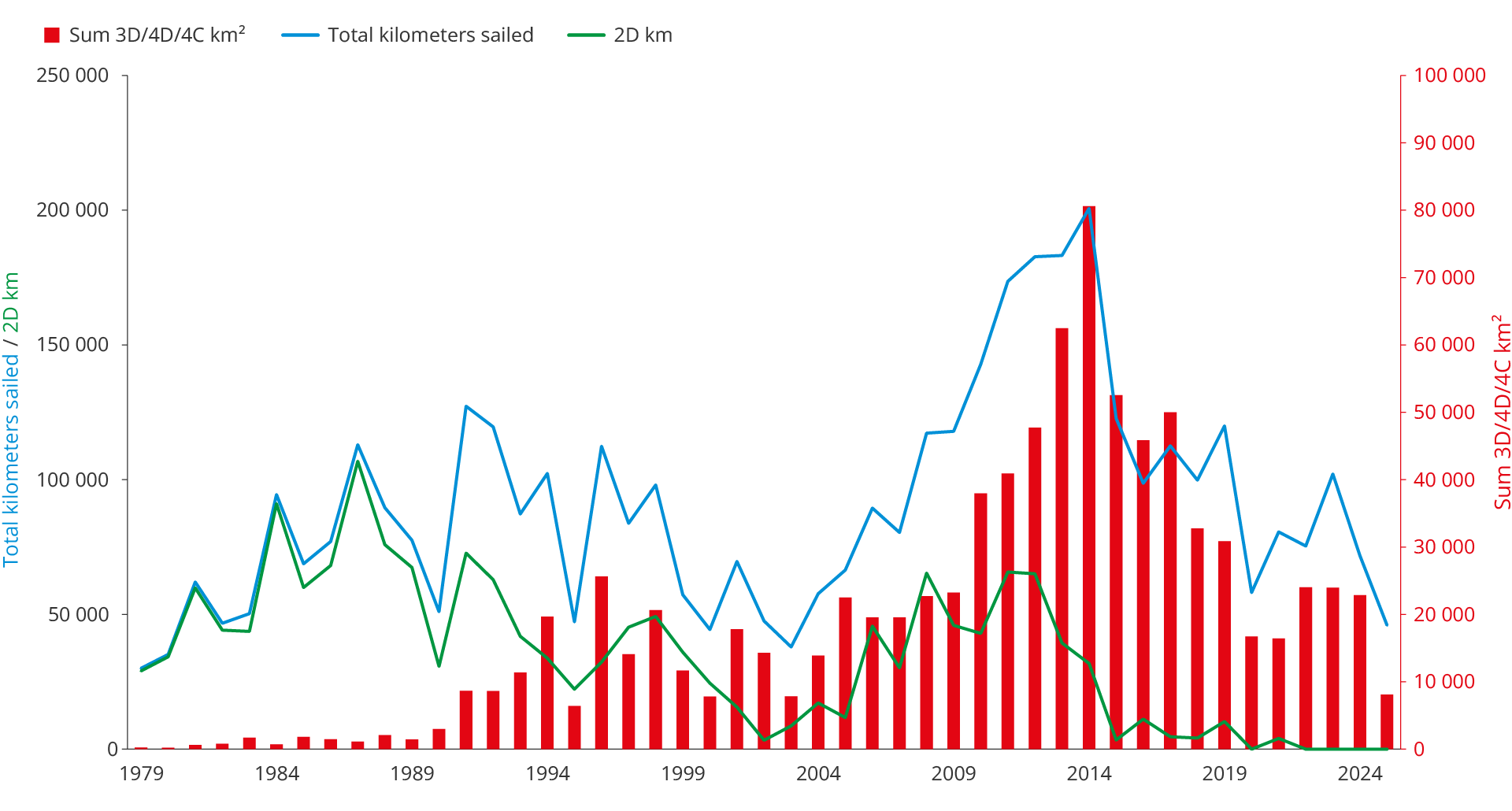
Figure 4.9 Historical acquisition of seismic data (1979–2025)
Diskos: 30 years of systematic data collection, storage and sharing
In 2025, Diskos (23) marked its 30th anniversary. The database was established in 1995 as a joint industrial archive for seismic data and well information from the NCS and has since grown to become one of the world's most comprehensive and publicly accessible petroleum databases.
The amount of data increased from around 16 petabytes in 2023 to around 22 petabytes in 2025 (24), a growth reflecting both increased activity and improved standardization of data formats.
For 30 years, Diskos has contributed to making the NCS one of the world's most data-intensive petroleum provinces. Systematic acquisition, storage and sharing of seismic, well data and reservoir information has resulted in a knowledge base garnering international attention (25). The combination of high data quality, vast geographical and geological variation and long timeseries of data makes Diskos a resource to which few other petroleum provinces have access.
Once the confidentiality period for a dataset has expired, the data becomes available to Diskos members. The database currently contains over 1,300 public seismic surveys with a total of over 24,000 data sets from the early 1980s up to the present. This is what makes the NCS unique: nowhere else in the world has so much seismic data been gathered in one place, nor been made accessible in this way.
In 2025, it became even clearer that this data base is an ideal starting point for training AI models adapted to Norwegian conditions, even though the data structure can be better adapted (26). AI and machine learning enable qualitatively different processing of large data sets, from seismic interpretation to well planning and reservoir simulation.
Measuring quality in AI models
It is challenging to assess how well an AI model answers complex academic questions. To measure the quality of responses to geoscientific and petroleum engineering issues on the NCS, the Force (27) consortium has published an open dataset with 1,100 questions and associated answers. The dataset is based on reports and data from Diskos.
The dataset provides industry and other players working on the subsurface on the NCS with a common basis for measuring, comparing and further developing the use of AI in professional analyses.
High well density per unit of area shows areas that are relatively well-explored, while low well density indicates areas that are less explored. The North Sea and parts of the Norwegian Sea are well mapped, with both high well density and good seismic coverage (Figure 4.10).
Layers
Figure 4.10 The map contains several layers which can be switched on and off. The layers show well density (wildcats), time (months) an acreage has been awarded, the number of times acreage has been awarded and the time since the last acreage has been awarded.
Central areas of the North Sea, particularly around Oseberg, Troll, Gullfaks, Sleipner and Ekofisk, are the clearest examples of well-explored areas. The same applies to large parts of Haltenbanken in the Norwegian Sea.
In the Barents Sea, the Hammerfest Basin is approaching a similar level of exploration. Even there, this primarily applies to the Jurassic levels, while deeper plays remain underexplored.
An area may be well-explored for known plays whilst still being stratigraphically underexplored. The central North Sea, for example, is well mapped in the Middle and Upper Jurassic, while pre-Jurassic and Palaeozoic levels have not been widely tested.
In mature areas such as the North Sea and parts of the Norwegian Sea, extensive conventional seismic data has been acquired, which has been reprocessed for better imaging. Near to existing infrastructure, seabed seismic is used to improve imaging and where acquisition of conventional seismic data is not possible.
Over the past ten years, technological developments have made seabed seismic more widespread. Increased processing capacity provides a better basis for decision-making than previously and enables larger surveys both for imaging reservoirs in the field and discoveries, as well as exploration opportunities (prospects).
Seismic methods in infrastructure-dense areas
Conventional streamer seismic and its limitations
In conventional marine seismic, sound pulses are sent from air gun arrays, while the signals are recorded by hydrophones in long cables (streamers) which are towed behind the vessel. The method is area-efficient and covers large areas per survey. Near infrastructure, streamer seismic is challenging, because the vessels must manoeuvre around fixed facilities. This restricts access to certain areas. Streamer seismic illuminates the subsurface in one direction, which can reduce image quality in areas with complex geology.
Multi-azimuth data (MAD) for better imaging
In areas with complex geology, it is advantageous to illuminate the subsurface from several directions. By combining streamer datasets collected in different directions, the processing can provide significantly better imaging than data collected in one direction. On the NCS, companies have in recent years acquired large data sets which are processed together with older seismic data, collected in other directions, to improve data quality.
Seabed seismic – two primary methods
In areas with dense infrastructure, the receivers are moved from near the sea surface to the seabed, while the source moves over the area. In practice, this provides data with a very high degree of flexibility. This approach is called Ocean Bottom Seismic (OBS) and incorporates the primary methods using subsea cable and subsea nodes.
Subsea cable (OBC)
Instrumented cables are deployed on the seabed from a dedicated vessel. This method provides better data quality than conventional seismic in infrastructure-dense areas, but the cable is relatively rigid. This requires careful planning around existing facilities and provides limited flexibility. Today, subsea cables are used less frequently. The industry has largely switched to subsea nodes.
Subsea nodes (OBN)
OBN uses self-contained, battery-powered instrument packages that are placed individually on the seabed using an ROV or special vessel. The nodes record data over a defined period and are then retrieved. The loose deployment provides high flexibility and makes it possible to place receivers close to facilities, pipelines and other subsea facilities. Data density and geometry can be adapted to the purpose, while the source vessel operates with greater room for manoeuvre.
Full-waveform inversion
Full waveform inversion (FWI) utilizes the entire seismic signal, allowing for improved and more detailed imaging of the subsurface. This leads to less geological uncertainty and more precise drilling decisions. Seabed seismic yields very good results in full-waveform inversion, because the data basis is abundant and provides imaging in all directions. This makes it easier to identify and develop even smaller prospects in mature areas close to existing infrastructure.
4D seismic and repeatability in producing fields
4D seismic, repeated seismic recordings over time, is a key tool for monitoring producing fields. The method is used to follow fluid movements, identify remaining resources and assess the effect of injection measures. On the NCS, 4D seismic is widespread in mature fields such as Ekofisk, Gullfaks and Oseberg.
For reliable 4D results, repeatability is essential. Large fields often have permanent reservoir monitoring (PRM) which gives the best repeatability. OBN also provides particularly favourable conditions because the nodes can be placed in the same location with high precision during repeated recordings. This provides more consistent data than with conventional seismic and makes OBN the preferred method in large, mature fields with a lot of infrastructure.
Advanced seismic technologies make it possible to detect small, complex or previously overlooked accumulations close to existing infrastructure. Examples are "Lofn" and "Langemann", which were discovered in 2025 in well-explored areas. The discoveries were made based on, inter alia, interpretations of new seabed seismic data and updated geological interpretations. This proves that there is potential also in areas considered to be well-explored.
Such findings are important, not only because they add resources, but also because they provide new knowledge. Better data quality, improved imaging technologies, AI and new geological hypotheses can change the understanding of the subsurface, even in the most explored areas.
Great opportunities in underexplored areas
Exploration close to existing infrastructure alone is unable to provide sufficient resource growth over time. A balanced exploration strategy must therefore combine continued activity in well-explored areas with measures that stimulate geological innovation and increased efforts in areas with higher resource potential and the possibility of larger discoveries.
Even in areas that have been opened for petroleum activities, there are still large areas of underexplored territory. This applies to large parts of the southern Barents Sea, parts of the deep-water areas and coastal areas in the Norwegian Sea and some areas in the North Sea. Such areas provide greater opportunities for major discoveries.
Underexploration is usually understood geographically, relating to areas with few wells, limited seismic coverage and immature play understanding. However, this approach does not capture the fact that even deeper stratigraphic levels and alternative plays within well-explored areas may be as little tested as areas that are geographical underexplored.
Areas may be poorly explored because they lack access to infrastructure, have not been opened for petroleum activities or incur high costs, for example, due to challenging distances and deep or complex reservoirs, making exploration less attractive.
Stratigraphic underexploration is largely due to technological limitations. Limitations in seismic imaging, immature play understanding and the operators' exploration strategy are particularly important factors. Capital discipline and a low risk appetite mean that companies often prioritise known plays with proven profitability rather than testing deeper or alternative stratigraphic levels, even in well-explored areas.
Knowledge externalities also contribute to certain areas being underexplored. Exploration provides knowledge, and the value of results from drilling, seismic data and geological models extends far beyond the benefits to the individual player. This may result in lower exploration activity than is economically efficient from a societal perspective. Government funding of stratigraphic wells, seismic mapping and more efficient data sharing through Diskos can help to reduce this market failure.
Knowledge externalities
Knowledge externalities arise when information generated by one industry player's exploration drilling accrues to other players without full compensation. Knowledge of geology, stratigraphic column, pressure/temperature regime, source rock and reservoir quality is largely non-excludable and non-rivalrous once it has been gathered. The party that drills bears the entire cost; many industry players reap the benefits of learning effects.
New source rocks and immature Plays
Widespread natural seepage on the Norwegian continental shelf
Natural gas and oil seeps are widespread on the NCS (28). Several thousand methane seep sites have been mapped on the seabed, mainly in the Barents Sea. This makes the region one of the world's most active for subsea methane emissions.
Natural oil seepage has also been proven in some places, including off the coast of Svalbard. In addition, oil slicks have periodically been observed on the sea surface in the southern North Sea.
The findings are based on research and surveys by the Norwegian Offshore Directorate and collaborating academic communities in recent years. The purpose has been to understand the underlying petroleum systems.
The surveys show that the seepage is largely controlled by geological conditions. The occurrence is particularly high where previous ice age erosion has weakened overlying cap rocks.
The studies have also revealed a previously overlooked, young source rock west of Svalbard. The discovery is based on geochemical analysis of oil from a seabed seep.
Young source rock in the Norwegian Sea – a possible new play
A young source rock widely distributed in the Norwegian Sea was proven in 2024 (29). The discoveries are based on studies of natural oil seeps and link these to early/mid-Miocene intervals in several scientific wells and exploration wells.
The source rock was deposited in a large delta, which can be compared to how the Niger and Congo deltas off West Africa look today. In many places, the source rock has not been buried deep enough to generate oil.
Basin modelling nevertheless shows that the source rock may be oil-mature where it is buried deeper, for example under Bjørnøyvifta, and may have an impact on exploration opportunities in parts of the existing APA area in the Norwegian Sea.
The Finnmark platform in the Barents Sea – immature plays:
The expanded APA area on the Finnmark platform includes several plays for further mapping. Seismic data show fault structures in the bedrock with possible structural and stratigraphic traps.
Norwegian Sea west – resources beneath the basalt
Available data and geological analyses indicate petroleum potential beneath volcanic deposits on the NCS, including in the western parts of the Møre and Vøring basins (30) . There is, however, considerable uncertainty.
The challenges are of both a geological and technological nature. Imaging beneath basalt layers is currently limited, which makes for considerable uncertainty in the interpretation of the plays.
Further development of geophysical methods can provide a better basis for exploration of these areas on the NCS, allowing the areas to develop into some of the most interesting exploration areas in Europe.
What is the problem with basalt?
Basalt can affect several key elements in a petroleum system and thus increase the overall geological risk. In areas with volcanic deposits, seismic imaging is particularly challenging, both in terms of the basalt layer and the structures below it.
Basalt reflects, scatters and absorbs seismic energy, which can create noise and multiple reflections, and results in very little signal penetrating the basalt and returning to the receivers. Variation between lava flows, breccia and vesicles gives further uncertainty in velocity models and depth migration. The signal is weakened, and the possibility to image deeper structures is diminished.
Heat from basalt and igneous intrusions can shift the maturation of source rocks and disrupt the interaction between hydrocarbon generation, migration, and fault development. Basalt has low permeability and can prevent migration, but cracks and contact zones can create unpredictable leakage pathways. In addition, basalt increases drilling and operational risk associated with hard rocks, low drilling speeds, high wear and reduced predictability in pore pressure and reservoir depths.
New seismic technology, better processing tools and AI-driven interpretation can help uncover plays currently unidentified. This applies particularly to deepwater areas in the Norwegian Sea and the marginal zone of established exploration activity, including in the Barents Sea.
Plays of this nature cannot be quantified with existing tools, because what is being searched for is unclear. They lie outside the current methodological and conceptual framework, not due to a lack of data, but because they require conceptual breakthroughs rather than the gradual collection of more data. Resources associated with such models are often referred to as unforeseen Resources (31) or "unknown unknowns", the ones we don’t know we don’t know (32).
Knowns and Unknowns
"Known knowns" are known fields and reserves in production. "Known unknowns" are undiscovered resources within established geological models which are included in resource calculations. "Unknown unknowns" are resources associated with plays that have not yet been conceptualised, and which therefore fall outside the existing estimation framework.
A fourth category is "unknown knowns"(33), which refers to knowledge which is implicitly present, but not explicitly articulated or problematized. In oil and gas exploration, this may refer to unspoken assumptions about which play concepts are "realistic", which reservoir types are considered commercial, or which provinces are perceived as mature. In practice, such guidelines form the basis for screening, interpretation and decisions, without necessarily being included in explicit models or estimates.
"Unknown unknowns" refers to the limits of what is conceivable, while "unknown knowns" refers to what is not challenged. Historically, new technology and geological innovation have shown the capacity to move resources from "unknown unknowns" to "known unknowns", and in some cases, all the way to discoveries. Important breakthroughs have also surfaced when established assumptions - what "everyone knows" - are challenged. In this respect, innovation in exploration activity is not only about discovering the unknown, but also about highlighting and revising the unreflected in the known.
Barents Sea – limited gas export capacity
The High North has the largest remaining resource potential on the NCS. Large parts of the Barents Sea are still underexplored, and significant areas have not been opened for petroleum activities. Realising this potential requires the development of infrastructure, particularly gas export capacity.
Hammerfest LNG – the only export capacity
Hammerfest LNG at Melkøya is currently the only operational infrastructure for gas exports from the Barents Sea. The facility is fully utilised by the Snøhvit field and is expected to be filled with proven resources until around 2050 (Figure 4.11).
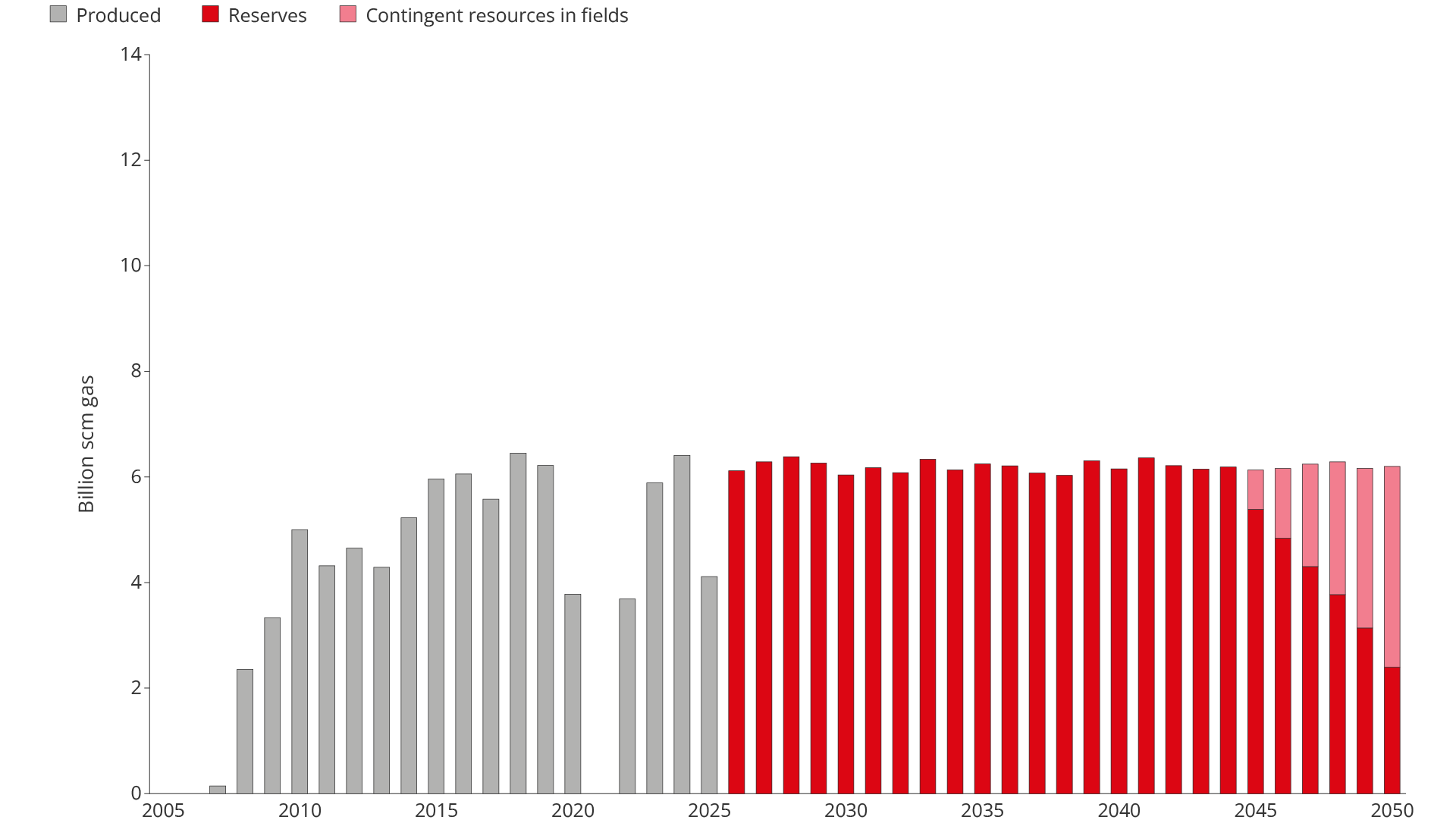
Figure 4.11 Possible trajectory for gas exports from the Barents Sea, given current export capacity
Remaining proven gas resources in the Barents Sea stand at approximately 230 billion scm, but limited gas export capacity (around 6 billion scm per year) is slowing down development.
The limited gas export capacity in the Barents Sea means that all resources in the area must compete for the same infrastructure. This applies to fields in production, discoveries under assessment and future discoveries. The result is a deferred income and weaker profitability. Without increased gas export capacity, there is a risk that significant resources with high value potential will be left behind, meaning that they will not be explored.
For oil fields with associated gas, increased gas export capacity enables more efficient operations. Surplus gas that is not needed for injection to increase oil recovery can be exported and sold. Wells that are currently being choked back due to a high gas proportion can produce close to their actual capacity, and the fields can be operated with more efficient drainage strategies.
Increased export capacity makes it possible to produce gas in line with the wells' actual delivery capacity, without being limited by available infrastructure. Gas discoveries can thus be put into production earlier and with a higher production rate from start-up.
Increased export capacity can contribute to faster development of the Barents Sea as a petroleum province in a period when the North Sea and the Norwegian Sea are in structural decline.
As illustrated in Figure 4.12, increased export capacity may result in spare capacity for proven resources and new discoveries up to 20–30 years earlier than under current limitations. This can secure a major value uplift for both oil and gas in the Barents Sea.
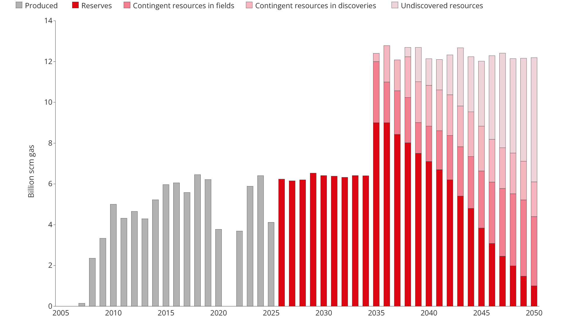
Figure 4.12 Possible trajectory for gas exports from the Barents Sea, exemplified by doubling export capacity
Gassco and the Norwegian Offshore Directorate have over several years analysed the basis for increased gas export capacity from the Barents Sea.
The 2023 study showed, inter alia, that increased gas export capacity can provide faster development of proven resources and be economically efficient from a societal perspective under given conditions (34). The analyses were based on a conservative resource base for both proven and undiscovered resources and did not include the effects on oil production.
In 2025, Gassco continued its work on assessing possible gas export solutions for the Barents Sea, resulting from the previous studies (35). Work was later paused pending increased resource growth from exploration.
Unopened areas – a sea of opportunities
The potential for making large discoveries is greater in unopened areas than in those already opened for petroleum activities, as these areas may contain new and unconfirmed plays here.
Historically, the first exploration wells in a new province have a systematically higher probability of proving large accumulations than wells in mature areas.
This is also the experience on the NCS. Ekofisk, Statfjord and Troll were all made at an early stage. The most attractive structures in a play are drilled first, and the discoveries are often far larger than those made subsequently in the exploration process.
An unopened province thus represents a different risk distribution; not necessarily a higher expected value, but a distribution with a greater probability of large discoveries.
The unopened areas on the Norwegian shelf are Skagerrak, Trøndelag I, Nordland IV–VII, Troms II, the western Norwegian Sea, the Western Margin, Barents Sea North and Jan Mayen (Figure 4.13). The areas cover large acreage and represent a wide spectrum of geological provinces, from coastal areas to deep-sea basins and Arctic regions.

Figure 4.13 Area status Norwegian continental shelf
Common to the unopened areas is that they are poorly mapped compared with areas open for exploration activity. The geological knowledge is derived mainly from scarce seismic data, shallow drilling, onshore surveys and experience from nearby open areas and comparable geological provinces. Data coverage varies and data quality is highly variable, resulting in consistently high geological uncertainty. The datasets are old and fail to meet the standard and quality of new datasets from opened regions.
In some areas, particularly in the northern Barents Sea, available data and mapped structures show considerable resource potential. However, plays and petroleum systems are largely unconfirmed, as no exploration wells have been drilled.
In other areas, such as Skagerrak and the most coastal parts of the Norwegian Sea, the resource potential is considered limited.
For the Western Margin and the western part of the Norwegian Sea, there is currently insufficient data to carry out quantitative resource assessment. New observations and ongoing studies of natural oil and gas seepage nevertheless indicate that active petroleum systems may be present. Further data acquisition is needed to reduce uncertainty and to provide a more robust basis for resource assessments.
The Jan Mayen area differs from other unopened areas due to extensive volcanism and complex geology. The resource assessments are therefore particularly uncertain, even though there are indications of potential plays in sedimentary sequences beneath and between volcanic rocks.
Profitability of exploration 2000–2025
In the period 2000–2025, exploration activity on the NCS has been extensive. More than 1,000 exploration wells have been drilled, of which around 730 are exploration wells and around 300 are appraisal wells. Total exploration costs in the period are estimated at close to NOK 800 billion. The costs include both successful and dry wells.
Methodology
The Norwegian Offshore Directorate's profitability analysis is based on revenues from discoveries made in the period 2000 to 2025, less all costs, including exploration costs and shutdown costs. Exploration costs include both exploration that has yielded discoveries and exploration that has not proven resources.
The income and cost basis is based on historical figures up to and including 2024. Future revenues and costs are based on the Revised National Budget for 2026 and the Ministry of Energy's calculation-based prices for oil and gas.
The cash flow has been discounted to the same year (2026), where a 7 per cent future discount rate and a 4 per cent historical discount rate have been Applied (36).
The exploration wells have resulted in approximately 370 discoveries, which corresponds to a technical discovery rate of around 50 per cent.
Of these discoveries, around 240 have either come on stream or are expected to be developed. Around 100 are already on stream, around 40 have received development approval and 100 are expected to be developed. The remaining discoveries are considered not profitable under current conditions, partly due to limited size or demanding conditions.
The developable discoveries represent total recoverable resources of close to 2,000 million scm oe. Total investments in development, as well as costs for operation and shutdown for the discoveries made during the period, are estimated at approximately NOK 2,700 billion. Total revenues from these discoveries are estimated at over NOK 9,000 billion (Figure 4.14).
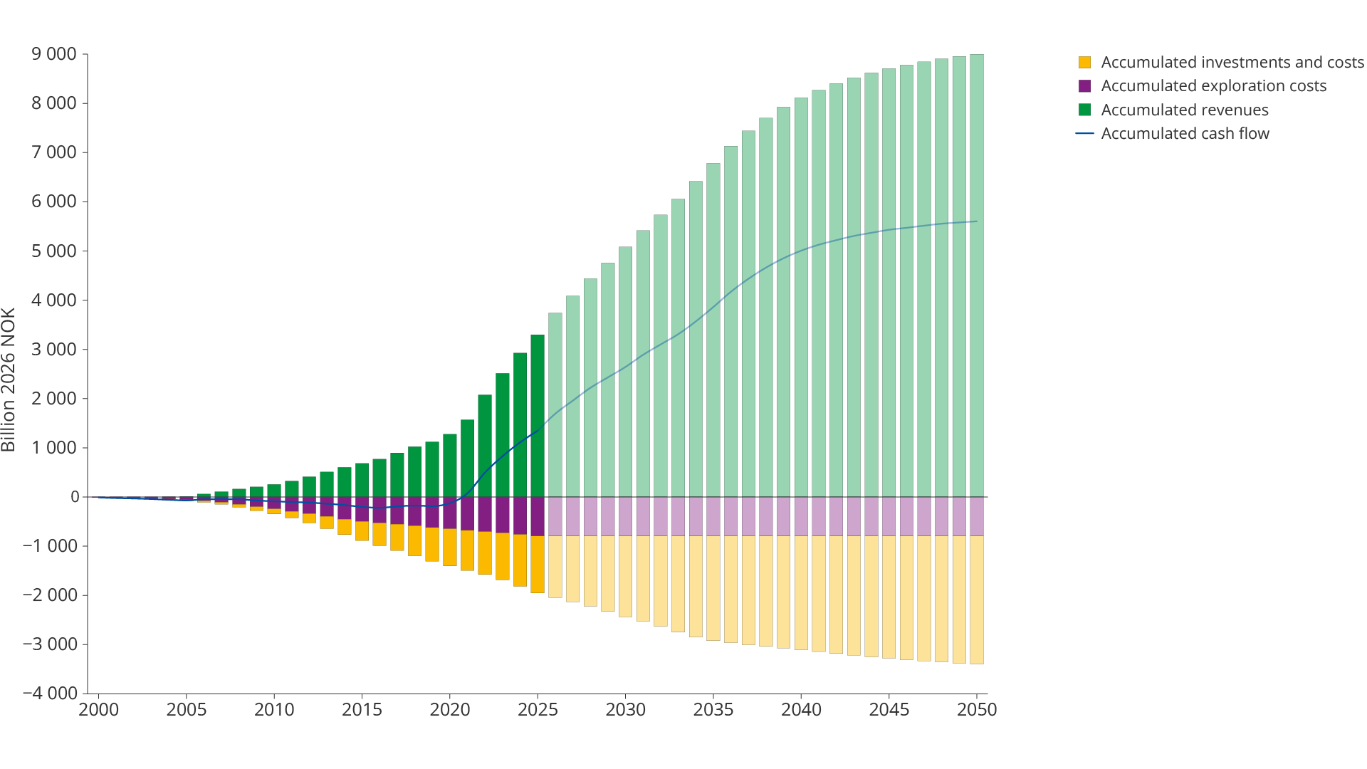
Figure 4.14 Estimated cumulative cash flow from exploration activities in the period 2000–2025
When all costs, including exploration costs, are deducted, this gives a total net cash flow of approximately NOK 5,500 billion. With a discount factor of 7 per cent, this corresponds to a net present value of almost NOK 4,000 billion (Figure 4.15). The figure shows that oil and gas exploration on the NCS during this millennium has been highly profitable.
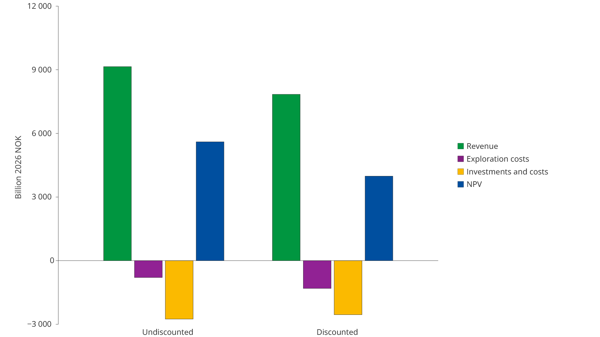
Figure 4.15 Net present value with revenues and costs related to exploration activities in the period 2000–2025
In Figure 4.16 profitability per krone spent on exploration is illustrated.
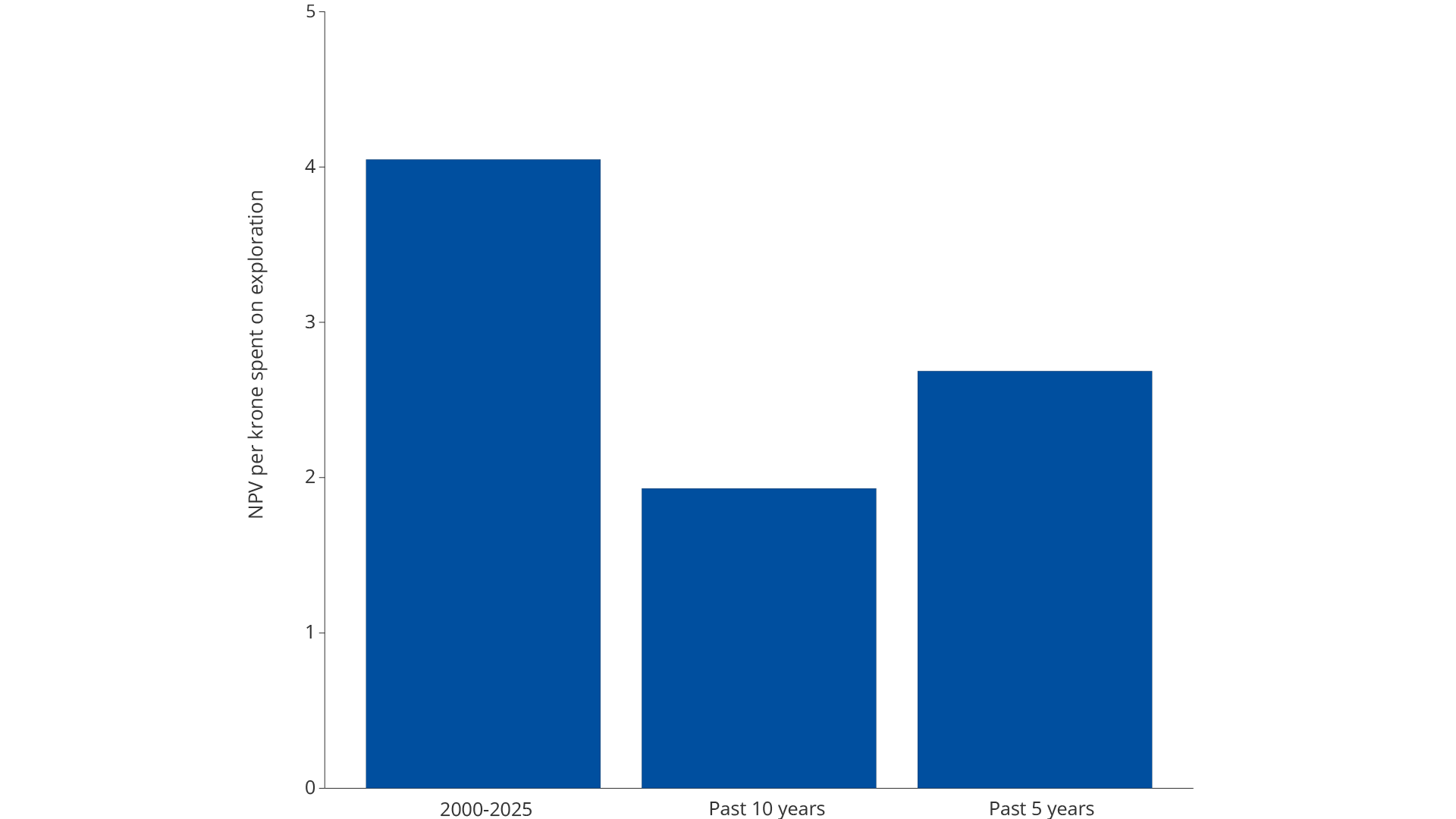
Figure 4.16 Profitability per krone spent on exploration
Every krone invested in exploration in the period 2000–2025 has returned approximately NOK 4. Several large discoveries in the first half of the period laid the foundation for highly profitable developments.
The last ten years have been characterised by higher discovery costs and smaller discoveries. Although these discoveries yield lower net present values than the large discoveries earlier in the period, they contribute to positive profitability from exploration activities overall.
Exploration on the NCS over the past ten years has returned close to NOK 2 per krone invested in exploration. Good exploration results and lower discovery costs over the past five years have increased profitability to over NOK 2.5 per krone invested in exploration.
The Norwegian Offshore Directorate's calculations show that exploration activities are profitable in all sea areas on the NCS (Figure 4.17). In the North Sea, each krone invested in exploration has returned just over NOK 5. The high profitability is related to the fact that the North Sea is a mature area with well-developed infrastructure and several large discoveries during the first half of the analysis period, including 16/2-6 Johan Sverdrup.
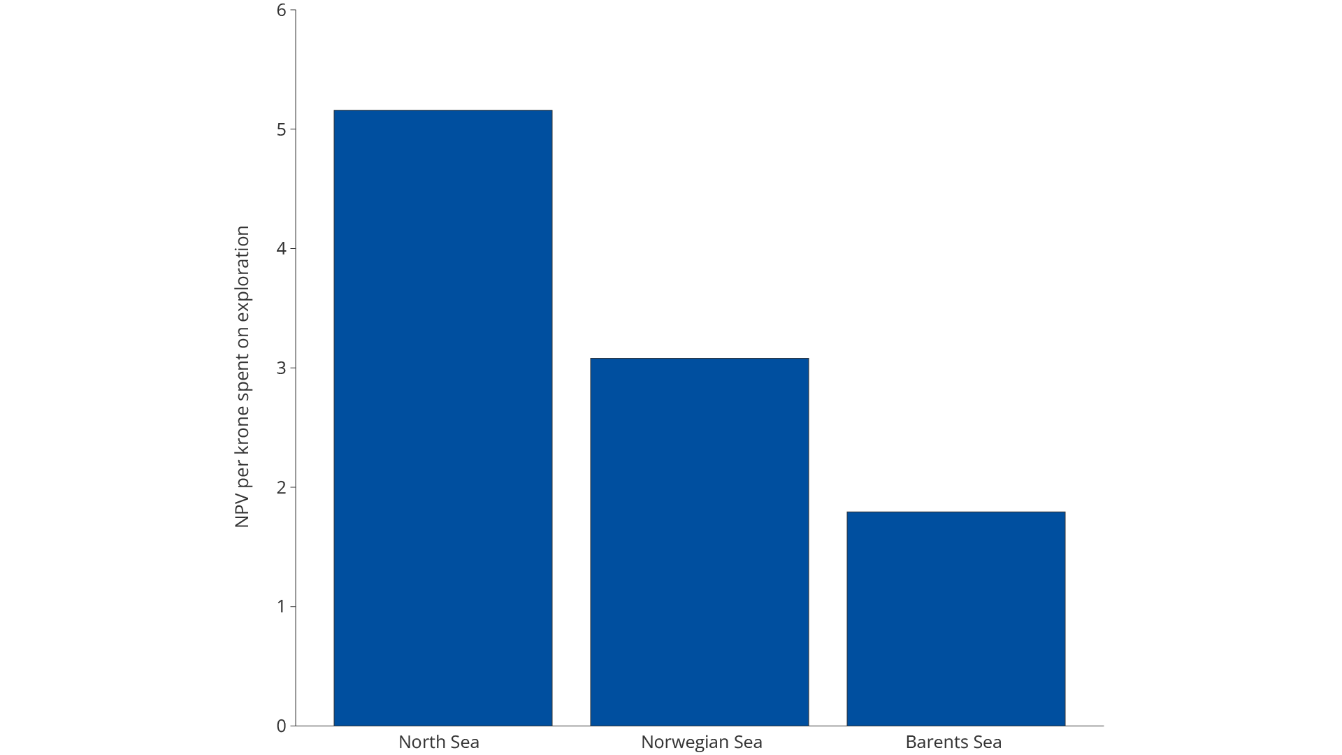
Figure 4.17 Profitability per krone spent on exploration by sea area in the period 2000–2025
In the Norwegian Sea, exploration returns approximately NOK 3 per krone invested in exploration. In the Barents Sea, the return is lower, but still positive, with a return of almost NOK 2 per krone invested.
Total exploration costs compared to the recoverable resources proven through exploration activities give an average discovery cost of approximately NOK 400 per scm oe. This equates to approximately USD 6 per barrel oe.
Additional values
The profitability analysis of exploration activities in the period 2000–2025 shows the direct economic costs and the direct financial revenues from discoveries made during the period.
Direct revenues include total revenues from recovery and sale of oil and gas, which in turn is determined by production volumes and prices of oil, gas and NGL (natural gas liquids). Similarly, direct costs will include investments, use of equipment, labour and energy for exploration, development and operation of the projects.
There are several additional values from exploration activities beyond the direct value of the profitable discoveries. These are not included in the profitability calculations. For example, most discoveries made today are not large enough to be developed as stand-alone projects but are valuable as satellites for existing facilities.
These additional volumes can make it possible to extend the field's lifetime significantly, which in turn can add considerable value. The longer a field is in production, the more resources it will produce, and the more new discoveries can be tied back to the field.
New discoveries can also postpone a costly shutdown of facilities on host fields, which can also be of significant value to surrounding discoveries and exploration opportunities. New discoveries also help to maintain a resource base for common infrastructure. The discoveries can keep pipelines, process plants and terminals operating longer and reduce unit costs for all users.
These are indirect additional economic effects, which in this context are revenues and costs not reflected in the basis for calculating the profitability of exploration.
Updated: 9/8/2026