Subsurface clarity
7/2/2026 Everything was simpler before. The geologists observed a “bump”(dome) below the seabed, the rig took up position and drilled in the middle. Today, everything is more akin to computer games.
Technological development within exploration drilling spans several dimensions.
- Time – provides increased knowledge about the shelf and various exploration concepts.
- Reflection – knowledge is processed, shared, and applied to see things in new ways. By experts.
- Improved data – old seismic data is like looking at a small selection of blurry black and white images. Today’s data shows the subsurface from every angle in full colour.
- Equipment – new knowledge about the subsurface, combined with infinitely better tools, i.e. rig and equipment, allows the operator to navigate in the subsurface and collect real-time data whilst drilling, which in turn helps determine further progress.
- Economy – the Norwegian continental shelf has resembled a laboratory for the companies due to the tax regulations governing research. When oil prices are high, increased exploration activity is stimulated.
The obvious, straightforward discoveries have been made, we are told, meaning the large discoveries such as Statfjord, Oseberg, Troll and Ekofisk. As well as others. Since we have a well-developed infrastructure on the Norwegian continental shelf, i.e. pipelines and platforms, new, smaller discoveries can be tied back to this system when spare capacity is available.
Profitability demands that the exploration wells must be cost-effective and accurate, which they have been, thus ensuring continued value creation from the NCS.
One line
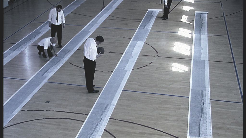
Before the digital era fully took hold, interpretation was carried out on long paper rolls featuring seismic printouts. These were unrolled in a large hall, and geologists would crawl around on the floor to interpret the seismic lines. (Photographer: Unknown)
In the early years, seismic imaging of the subsurface was conducted by a vessel towing one seismic cable. These cables capture the reflection of pressure waves which are then "shot" into the subsurface. This gave the field experts two-dimensional images of the subsurface.
The number of seismic cables in tow has since been expanded to eight and occasionally even more, resulting in three-dimensional images.
By placing the cables on the seabed, or behind the vessel, and repeating seismic surveys every second year, for example, a fourth dimension was made possible.
Today, nodes can also be placed on the seabed prior to seismic data acquisition. This has further improved the quality of the data collected.
Two dimensions
With two-dimensional seismic, the uncertainty of the mapping of the subsurface was greater. Geologists used professional knowledge and calibrations from analogues on land to "fill the knowledge gaps". The seismic data was printed on meter-long rolls, whilst the geologists knelt in a large room and coloured in the printout using coloured pencils.
They focused on the large "bumps", several of which make up the large fields on the NCS today. We might say that we have picked the low-hanging fruit.
We have more or less run out of "large bumps", at least in the mature, well-explored areas of the shelf. Today, most discoveries are smaller, often in more complex structures than before. This requires the experts to think innovatively to understand the petroleum systems on the Norwegian continental shelf.
Computing power
Today, subsurface imaging technology is significantly more advanced. Also, the computing power that processes the seismic data is completely different. In addition, field experts have started using artificial intelligence to interpret the data.
This allows exploration wells to be positioned with significantly higher precision than previously.
Positioning the wells better and choosing to drill on the right prospects has led to a current hit rate of almost 50 per cent, but not all discoveries are financially profitable. They may be too small or too far from existing infrastructure. Previously, the probability of discovery was lower.
Today's challenge is to find and exploit small discoveries economically. For this to happen, understanding and technology need to improve.
The longest exploration well
Aker BP utilised exploration technology to the max when the company initiated a drilling campaign near the Yggdrasil area in the North Sea.
The campaign included five exploration targets – Omega, Alfa, Alfa Sør, Sigma NE and Pi – which were explored via a multilateral well, west of Yggdrasil.
Drilling operations commenced in May 2025 using the Deepsea Stavanger rig. Over the course of three months, a total of 45,000 metres were drilled, of which 40,000 metres were in reservoir sections. This included the three longest wellbores ever drilled on the Norwegian continental shelf, with the longest at 10,666 metres.
The horizontal wellbores made it possible to collect enormous amounts of high-resolution reservoir data. This has significantly reduced the uncertainty in the subsurface. The operator conducts data acquisition during drilling. Electromagnetic signals are used to show the rock formations ahead, allowing the next direction of the drill to be determined. Multilateral wells from a single top hole and long wellbores allow multiple prospects to be assessed in a single drilling operation. A prospect is a potential petroleum deposit which has not yet been drilled, but which has been mapped and calculated in terms of volume.
In this case, the discovery added between 15 and 21 million standard cubic metres of oil equivalent (between 96 and 134 million barrels) as new resources to the Yggdrasil area. Omega Alfa is among the largest commercial discoveries made on the Norwegian continental shelf in the last decade.
The Omega Alfa campaign was carried out in production licences 873, 873 B and 1249, all operated by Aker BP, with Equinor, Orlen and Petoro as partners.
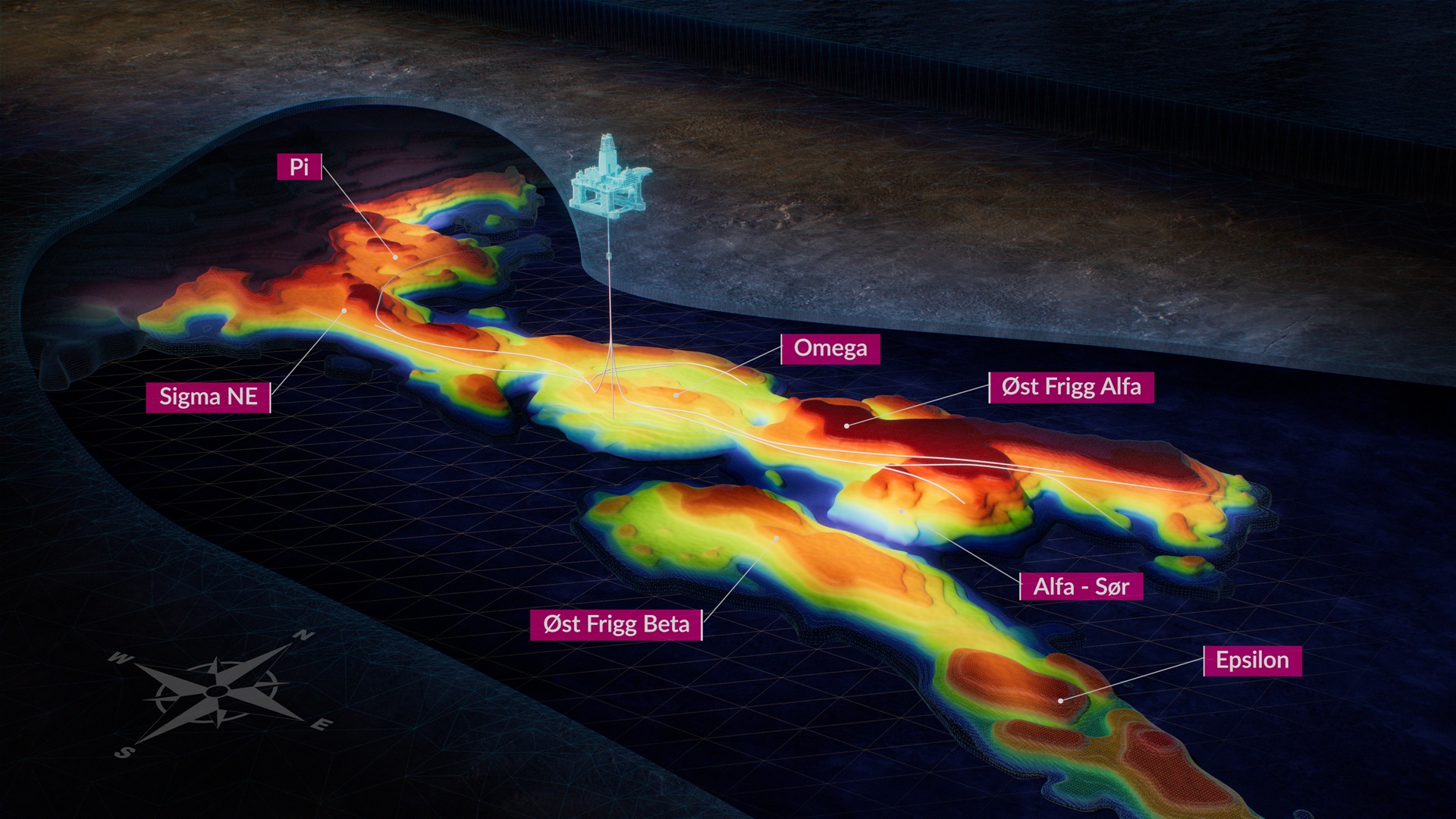
Illustation: Aker BP.
More boldness is needed
The drivers in exploration today are strategy and economics. In the past, companies looked to make large discoveries and build large platforms. Today, 80 per cent of exploration is conducted close to existing infrastructure. Discoveries can be phased in, and small discoveries can thus become economically profitable.
The downside of this is that the companies may not dedicate sufficient resources to innovative thinking and new exploration models – which are needed to make new, major discoveries.
Comprehensive process
The companies apply for and are awarded production licences. The permit is like a leasehold plot, which comes with obligations/work programs within a given period. The company is also entitled to produce petroleum from the production licence.
Firstly, the partnership must decide whether to drill. If it drills and makes a discovery, the companies have several years to decide on how to extract those resources. The plan must undergo an environmental impact assessment and be approved by the authorities. The field development typically takes several years before production can start.
Subsurface clarity
Updated: 7/3/2026